

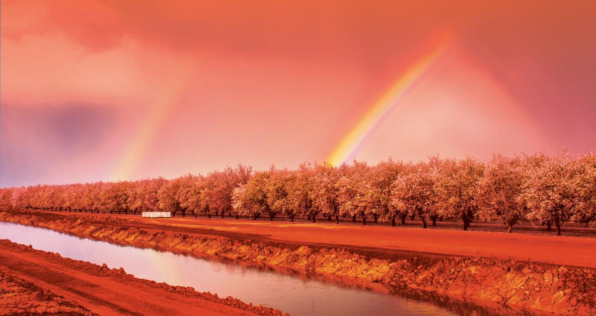
Dr. Jay Lund, director of the UC Davis Center for Watershed Sciences, is the godfather of research on the Sacramento-San Joaquin Delta. When he says it took John Sutter eight days to wind his way from San Francisco Bay through the Delta to find the narrow Sacramento River in 1839, you can bet that’s the truth. Not until 1913 was the mouth of the river dredged to make it a mile wide. Grizzly bears roamed the wildness, feasting on an abundance of native fish, until they were hunted to local extinction. Today in the Delta, the largest estuary on the west coast of North America, only remnants remain of the natural landscape before it was irreversibly altered at the hands of people.
The Delta is a system of canals. In places, you can stand on a man-made levee with high water on one side and sunken land on the other. For 7,000 years, sediment accumulated to form deposits of organically-rich peat soil, but the last 170 years of farming have undone this natural process. About 2,300 dump trucks worth of soil is lost per day, oxidized as carbon dioxide and all told, about half of the Delta’s soil material is now gone, says Curt Schmutte, a civil engineer who specializes in Delta issues. We named plots of land in the Delta “islands,” but scientists refer to them — the majority below sea level — as “holes.”
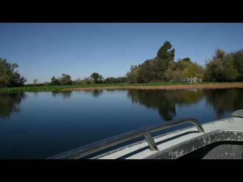
I’m with a tour group on a hot September afternoon, and we hold onto our hats and brace ourselves as the boat tears through the water at 40 miles per hour, past invasive water hyacinth, tules, fishermen, houseboats, farmland and cattle. The Delta accumulates water from California’s largest watershed and acts as the hub of the state’s water supply system, linking water from the north to the two biggest water projects, which play a major role in sustaining the world’s sixth largest economy and much of its industry, agriculture and 39 million people.
But the Delta exists under unrelenting pressure: from land-use change, population growth, nutrient pollution from wastewater treatment plants, earthquakes, agriculture, sea-level rise and more. Even with money, there’s no silver bullet to fix this ecosystem — but there are plenty of battling sides. “It’s like a game of chicken,” Lund says. “How do you break a game of chicken?”
Dr. Jay Lund, director of the UC Davis Center for Watershed
Sciences, while on a tour of the Sacramento-San Joaquin Delta.
(Photo by Sonya Doctorian)
")
Was it Mark Twain who proclaimed, “Whiskey is for drinking; water is for fighting over”? When it comes to this natural resource, our state is rife with conflict. And, perhaps, in the Sacramento region, open to resolution. While the state is all-consumed with water wars, the region’s efforts toward collaboration are easy to overlook. The best example is the landmark Water Forum Agreement, which 22 water agencies from Sacramento, El Dorado and Placer counties signed in 2000 to balance the environmental and human needs of the lower American River.
Now, water agencies have joined together again to launch the River Arc Project. Proponents say the project has the potential for a groundbreaking impact. It would help recharge groundwater through a management practice called “conjunctive use.” It would also allow for ongoing growth by creating an additional source of water to lessen demand on the lower American River and Folsom Lake, which already provide drinking water to 1 million residents, says Andy Fecko, director of resource development at Placer County Water Agency. “What’s unique about our region is we’re doing this before we have a crisis.”
Duking It Out Over Water
First, to understand why it’s so unusual for a story of optimism when it comes to water, we have to understand why water in California is often tied with conflict: Our water supply is limited and dispersed unevenly. And our water rights system is often deemed “byzantine” and “antiquated.”
Throughout the American West, precipitation falls in a different place than where most of us live. Early settlers realized that towns and agriculture in the frontier could only be sustained by moving water. So we built a complex system of dams, reservoirs, canals, aqueducts, pumps and tunnels. Who exactly has access to our state’s water has been a point of contention ever since. “It’s a Western pastime to argue over water rights,” says Rita Sudman, who served for 34 years as executive director of the nonprofit Water Education Foundation in Sacramento.
California has a dual water rights system when it comes to surface water. The system incorporates both riparian rights (for those who own land next to water) and prior appropriation (“first in time, first in right”). The Water Commission Act of 1914 established the permit process for obtaining surface water and formed the State Water Resources Control Board. Those legislators failed to regulate groundwater, not foreseeing what would come decades later as most of the state battles severe drought and the Central Valley sinks in places due to over-pumped aquifers. In some places throughout the state, groundwater extraction exceeds natural recharge (something the Sustainable Groundwater Management Act of 2014 aims to remedy).
Bulldozers collect and rearrange gravel to improve habitat for
fish in the lower American River. (Photo by Sena Christian)
")
Water battles led to an amendment to California’s constitution declaring that all water — surface water, groundwater, marshes and wetlands — must be for a reasonable and beneficial use, such as agriculture, commercial fishing, hydroelectric generation, municipal use, endangered species and recreation (like swimming or whitewater rafting). The definition allows for changing interpretations, and groups who perceive their interests to be in conflict — farmers, industry, environmentalists, outdoor recreationists — continually maneuver for their position to be prioritized. Arguments ensue.
Ultimately, our system works because it’s flexible, Fecko says. Californians get around labyrinthine water rights through water transfers (although experts say informal sales are inadequately tracked and come with their own problems on the open market, like skyrocketing costs for farmers whose water allotments have been curtailed). PCWA often sells surplus reservoir water to other water-strapped purveyors, which keeps rates low for its customers. The mechanisms currently in place get water to where it needs to be, Fecko says, adding, “There’s a better way to spend our time than unravel 102 years of jurisprudence.”
Areas of Agreement
The world of water districts is diffusive. We have a lot of them in California — over 1,200 and that’s only counting those elected by voters, or governed by a county board of supervisors or a city council. (That figure comes from the Legislative Analyst’s Office and is more than a decade old; other sources estimate around 2,000 districts, when including entities such as mobile home parks and mutual water companies.) The state also has 108 investor-owned water companies regulated by the California Public Utilities Commission.
Around 25 water purveyors operate in Sacramento County. These agencies work in the same river, the same watershed, the same groundwater basin. Theoretically, this poses a problem. “They each have their own boards, politics, priorities, water sources and water rights, and ways of doing things,” says Dr. Jeff Loux, an environmental planning professor and associate dean at UC Davis Extension. “Getting them to work together is a monumental task.” But, he says, that’s what the Sacramento region has done for two decades.
“We need to plan for a 10-year drought or more. If we are not planning, then we are not planning for the world we live in with climate change,” Loux says. To be able to effectively plan, agencies need to agree on stuff. They need to collaborate. “That is, to me, the place where progress gets made,” Loux says. He points to a prime example: the Water Forum Agreement.
“We’re doing good stuff, and we have the cooperation of water suppliers in the region. It’s not their primary mission to take care of the environment, but they realize it also takes care of their primary mission, which is delivering water to their customers at the lowest possible cost.”Tom Gohring, executive director, Water Forum
Member utilities provide $3.80 per water connection per year for the nonprofit organization that oversees the agreement. “For the cost of a latte per family, we get the Water Forum,” says Executive Director Tom Gohring. The agreement outlines the management of the lower American River. Fed by the Sierra Nevada, the American River is the second-largest tributary to the Sacramento River, which empties into the Delta and eventually the San Francisco Bay. But hydraulic mining during the Gold Rush and dams built along the American River dramatically changed the geology.
The lower river is a highly-altered habitat. It’s also home to 43 fish species, including the Central Valley steelhead and fall-run Chinook salmon, which are struggling. In 2006, the Water Forum developed a standard to establish how much water should flow through the river to provide adequate fish habitat. The standard also addressed goals for water temperature — high temperatures can kill fish. The U.S. Bureau of Reclamation immediately started implementing the voluntary standard at Folsom Dam. Folsom Lake is a critical part of the statewide water delivery system, balancing water needs for residents and businesses in the Sacramento region, agriculture in the Central Valley and the imperiled Delta ecosystem.
But the state’s historic drought showed that the standards didn’t go far enough. Dramatically lower water levels in reservoirs and rivers from the current drought have increased water temperatures, decreased flows and made fish spawning and rearing more difficult. Additionally, Folsom Lake is drawn down by sending freshwater from it to the Delta to combat encroaching saltwater from the rising Pacific Ocean.
So in 2015 the Water Forum drafted a new standard (not yet adopted) to set aside more water in Folsom Lake during wet years to lower temperatures and improve water flow conditions for fish in dry years. Underlying this recommendation is the scientific evidence that water temperature greatly impacts the fish in the American River, who are adapted to pristine, icy waters in the Sierra Nevadas but travel down to Sacramento Valley’s relatively warmer waters. Any fraction above 65 degrees is unhealthy for the fish; as of late-summer, the average daily temperature of the lower American River was 68 degrees.
Infographic: Imagine a Capitol Mall Rain Garden
On a September morning in Fair Oaks, Gohring drives his car down a bumpy fire road at Sacramento Bar in the American River Parkway to the Water Forum’s current river restoration project: The piles of rocks from a large gravel bar don’t look like much, but they will eventually be washed and sorted, then arranged by large bulldozers — running on vegetable oil and capable of entering the river — to create spawning and rearing habitat for salmon and steelhead. About 50,000 cubic yards of gravel have already been processed, creating over five acres of high-quality habitat, says Project Manager Lilly Allen.
This is the Water Forum’s seventh restoration project over the past eight years, done in conjunction with the city, state and federal governments. Allen estimates a budget of $800,000 for construction and $300,000 for monitoring. Another big part of their job has been to hold public meetings for neighbors. “You see bulldozers on the parkway and we want to let them know we’re not building condominiums,” Gohring says.
He lists off the reasons people should care about this project: “If you care about ecology: We’re trying to make sure our main fish species survive and recover. If you care about water rates and water supply: If those species continue to decline, you can expect that we will be facing drastic regulatory challenges.” Urban water use could be dramatically curtailed. Lawsuits would be filed. As he speaks, bulldozers dump their loads. Workers from the City of Sacramento’s utilities department are tasked with finishing the project by early October.
“This is why I love this job,” Gohring says. “We’re doing good stuff, and we have the cooperation of water suppliers in the region. It’s not their primary mission to take care of the environment, but they realize it also takes care of their primary mission, which is delivering water to their customers at the lowest possible cost.”
As I walk back up the fire road to leave, a man and his black labrador pass me, and he comments on the work. It’s been neat to watch the progress, he says. He used to live nearby and still returns to wade in the river. “Anything to help the fish,” the man says, walking on as his dog stops briefly to offer a parting glance.
Sharing a Limited Resource
“Conjunctive use” — remember that term. It’s of the utmost importance to how the Sacramento region will adapt if drought becomes California’s new normal. Conjunctive use refers to maintaining a more stable supply of groundwater by water purveyors switching between the use of groundwater in dry years and surface water in wet years. Here in Sacramento, agencies rely on groundwater and surface water, but usually it has been either/or. (Treated wastewater is also increasingly used in landscape irrigation and for industrial needs.)
Take the Sacramento Suburban Water District, which was historically groundwater-only. As the area grew quickly and more water was needed for residents and businesses, groundwater levels sank. “It was not a sustainable situation from a public good perspective,” Fecko says. In the mid-1990s, Placer County Water Agency agreed to supply SSWD surface water in wet years; to do so, SSWD built a pipeline from Folsom Lake to its service area. Since the project began 16 years ago, about 300,000 acre-feet of groundwater have been banked through natural recharge (1 acre-foot is about 326,000 gallons; enough to supply about four families with water for a year). The aquifer went from overdraft to balance.
“What is remarkable is the degree local agencies have gotten together and consolidated operations. They do so in very complex water-right contracts and legal settings.” Dr. Jay Lund, director, UC Davis Center for Watershed Sciences
“Our insurance policy against drought is groundwater and conjunctive use,” Gohring says. “It’s been a huge resource that’s helped us through the last drought and I think it will become more important in the future as growth continues to occur and as we look at the potential impacts of climate change.”
John Woodling, executive director of the Regional Water Authority, agrees. RWA formed in 2001 and represents 21 water providers and a handful of other associates and affiliates in Sacramento, El Dorado, Placer, Yolo and Sutter counties. Woodling says RWA’s $43 million American River Basin Conjunctive Use Program “served the region well during 2014 and 2015 when surface water supplies were threatened by low storage in Folsom Reservoir.” The program has funded infrastructure to divert and treat surface water, pipelines to move water and wells to use stored water when needed.
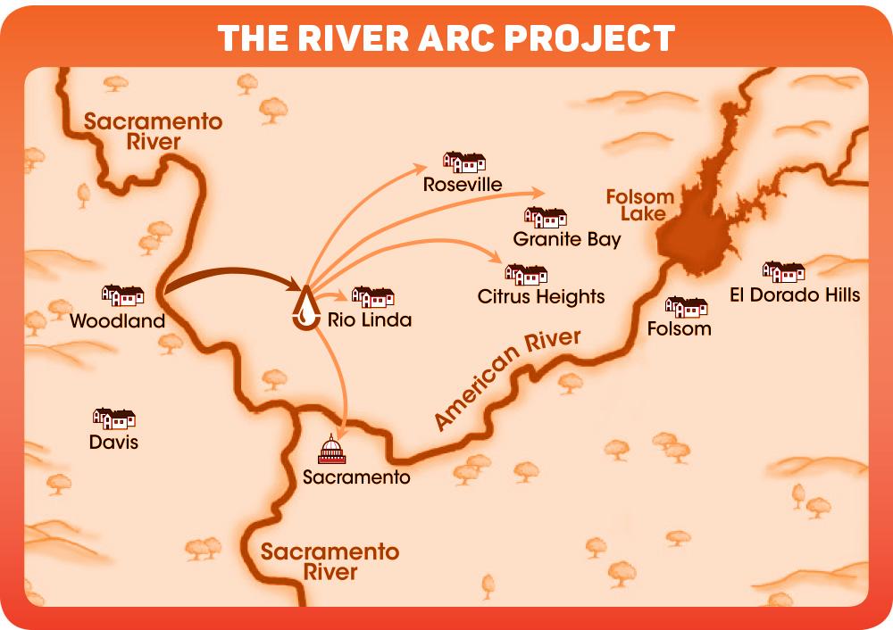
The River Arc Project would make use of an existing water
diversion facility on the Sacramento River. (Photo courtesy PCWA)
")
“While Folsom Reservoir must serve statewide water supply and environmental needs, the groundwater basin can serve as the Sacramento region’s reservoir, available to meet our needs into the future,” Woodling says. “In fact, it’s estimated that there’s more storage space available in the groundwater basin than twice the capacity of Folsom Reservoir.”
Being able to use this basin more effectively as storage protects against the environmental and economic impacts of drought. It will also enable the Capital Region to grow in accordance with the area’s general plans — and potentially without taxing the American River and Folsom Lake even more. While conjunctive use can theoretically be done by individual agencies with their own infrastructure and in their own service areas, Woodling says regional collaboration makes this approach more successful and reduces the cost burden.
Lund, of UC Davis, also says most of the region’s water storage is in groundwater — not above-ground reservoirs. “If you want to save water for dry years, it’s groundwater,” he says, later adding, “What is remarkable is the degree local agencies have gotten together and consolidated operations. They do so in very complex water-right contracts and legal settings.”
How can we get more surface water to ensure conjunctive management is an option? Enter the River Arc Project, a scheme to create three independent surface water sources for agencies in the region that have historically relied heavily on Folsom Lake and the American River, by tapping into the Sacramento River. In the early aughts, a handful of water agencies began exploring the use of an existing water diversion facility on the river near the Sacramento International Airport, constructed for agricultural needs and recently upgraded with state-of-the-art fish screens. A new pipeline would move water inland for treatment for residential and commercial use before sending it to northern Sacramento County and western Placer County.
This project would also safeguard against water shortages that aren’t drought-related, like a chemical spill in a river. But the project remains up to 35 years away from completion and will cost an estimated $800 million. “We’re in the early stages of the design, environment review, business plan,” Fecko says. “We’re at the 10 percent level. We’re excited because we know it’s going to move forward, but it’s a long-term proposition.”
Richard Plecker, director of Environmental Utilities for the City of Roseville, says tapping into the Sacramento River would diversify the city’s water supply portfolio. The city relies mainly on Folsom Reservoir, and has created a groundwater system and recycled water program. “In theory, [River Arc] might allow Roseville to access all of its water supply contracts and potentially reduce our demands on Folsom Lake, which could provide environmental benefit for the lower American River,” Plecker says. His department is still investigating the project’s merits.
River Arc might be funded by three pots of money: existing ratepayer money, prospective customers who will need to pay for water connection charges and the Proposition 1 water bond. “We’re making a strong case, but I don’t know how much of it [the state] is going to fund,” Fecko says. California voters passed the bond in 2014, authorizing $7.5 billion for water projects.
“It’s worth noting that conjunctive use and River Arc are important pieces of a vision for water reliability in the Sacramento region that local water providers have been working on for decades,” Woodling says. Two other key pieces include tweaking operations at Folsom and the lower American River to benefit both water supply and the environment, and promoting water efficiency as a way of life.
A boat tour through the Sacramento-San Joaquin Delta. (Photo by
Sonya Doctorian)
")
Out On The Delta
“Listen up!” shouts Jon Burau, whistling to get the group’s attention. Burau is project chief for the U.S. Geological Survey in Sacramento. “When we go around the corner, you’re going to see the best of the best.” We (a group of journalists from around the U.S.) approach a rice field in the Delta farmed until 1992 when a levee broke and flooded the land. Nature — remarkably and as it tends to do when left alone — took over. This area represents what happens when scientists work in alignment with nature; or, at least, when they stay out of the way.
As we travel through the Delta, we’re given a sense of the interconnectedness of California’s water system, which means that even though Sacramento’s water agencies may be a “collaborative spirit,” as Gohring says, they will always be entangled with, for better or worse, the rest of the state. There’s no getting around that reality. It’s a result of our state’s history, our politics and our hydrology. But there’s reason for hope.
While the Delta — the center of it all — may have a struggling fish population, it hasn’t been wholly eliminated. And while the estuary is fragile, it still helps support the state’s $54 billion agriculture industry. The state is requiring groundwater management and improving how it oversees water rights. A conservation ethic has spread among urban water users. And the value of conjunctive use in safeguarding against drought has become mainstream.
We end the tour pulling up alongside a narrow barrier of land that stands between farmland and a marsh. This spot is primed for a restoration project, to join around 10 other projects already underway throughout the Delta. “We do a terrible job here,” Lund says. “We do a horrible job here. But compared to every other mediterranean climate in the world — in population supported, the size of our agriculture, the condition of our native species — we do pretty well.”
Comments
Outstanding. And thank you for allowing Rita and me to contribute to this very critical issue.